Patricia lived for only four days, but will probably be remembered for years.
Patricia is the friendly name that was given to one of the most astounding weather events in the history of mankind. On the 20th of October 2015, over the waters of the Pacific Ocean, a harmless and nameless tropical storm suddenly transformed into a frightening category 5 hurricane. Taking everybody by surprise, the supercharged storm vaporized the world record for most rapidly developing tropical system in history. When Patricia touched ground in Mexico at the peak of its intensity, gusts of wind were measured at a record-breaking 340 km/h, roughly the speed a Ferrari F40 is able to reach. The pressure in the eye of the hurricane was so low, experts say it could have lifted the sea level up five meters. However, as soon as Patricia moved inland, it was cut off from its fuel supply – the abnormally warm waters of the Pacific – and dissipated into oblivion in less than 24 hours. Miraculously, not a single human casualty was left in its path.

Nothing of that sort had ever happened since the advent of modern technology. Neither had mankind ever witnessed three simultaneous category 4 cyclones in the Pacific… until August 2015. «They were even six tropical cyclones at one point in the Pacific Ocean, says Katy Hill, physical oceanographer working for the Global Climate Observing System secretariat at the World Meteorological Organization (WMO) in Geneva. There are some suggestions that the cyclone hyperactivity this year is related to the abnormally warm waters of the Pacific Ocean.»
There it is, the heat is once again responsible. The usual suspect already stands accused, and the jury presents its verdict: global warming is found guilty of all charges. Next case please !
It all makes perfect sense. Except the vast majority of experts says it doesn’t. Or as Ben Freeston, swell forecaster and founder of the website Magicseaweed – one of the oldest and most visited surf forecast website – puts it: «Anyone trying to tie every extreme weather event to manmade global warming is making a mistake».
Okay, so as a species, we are artificially making our planet warm up, but it is not necessarily the root of all evil. For instance, a recent international report examined 28 extreme weather events in 2014 such as wildfires, snow storms, cyclones etc. The scientists came to the conclusion that half of them could be related to manmade climate change, to various extents. The other half are entirely genuine.
It’s important to know that there are natural cycles that also heat up and cool down the world. These cycles can last from several weeks up to hundreds of thousands of years. For example, the sun’s activity is unstable and its radiation influences the temperature on Earth. Secondly, the Earth’s obliquity varies continuously, changing the angle of the rays we receive from the sun. Thirdly, our planet’s orbit around our main star is elliptical, which means we are sometimes closer, and sometimes further away from the heat source. Finally, the volcano activity also plays a role in the increase or decrease of temperature.

Although these natural cycles have been happening for millions of years, it is undeniable that mankind is accountable for some of the rapid warming of the planet. Since the industrial revolution of the 19th century, our activities have been so intense that some of the sun rays that used to be reflected back into space are now trapped here. It’s the greenhouse effect, and the main culprit is a gas called carbon dioxide, or CO2. More greenhouse gas being released in the atmosphere means more sun rays and heat. More heat means more energy in the weather. It’s a bit like giving a shot of espresso to an already angry kid. «We need to expect more extreme events, says Katy Hill from the WMO, because we are bringing instability in the climate system».
Every single one of the weather events that impacts us humans, extreme or harmless, happens in the sky or on land. When we talk about the climate, we point our noses upwards. What we should actually be doing is looking underwater. The fact is that 90% of global warming takes place in the oceans. Brian King, expert in ocean circulation at the National Oceanography Center in the United Kingdom explains: «The air doesn’t weigh much so it doesn’t take a lot of energy to warm up. On the other hand, the land is solid, so heat doesn’t penetrate further than a few meters. What’s left is the water, which can move around and mix and allow the extra heat to penetrate deep in the ocean.»
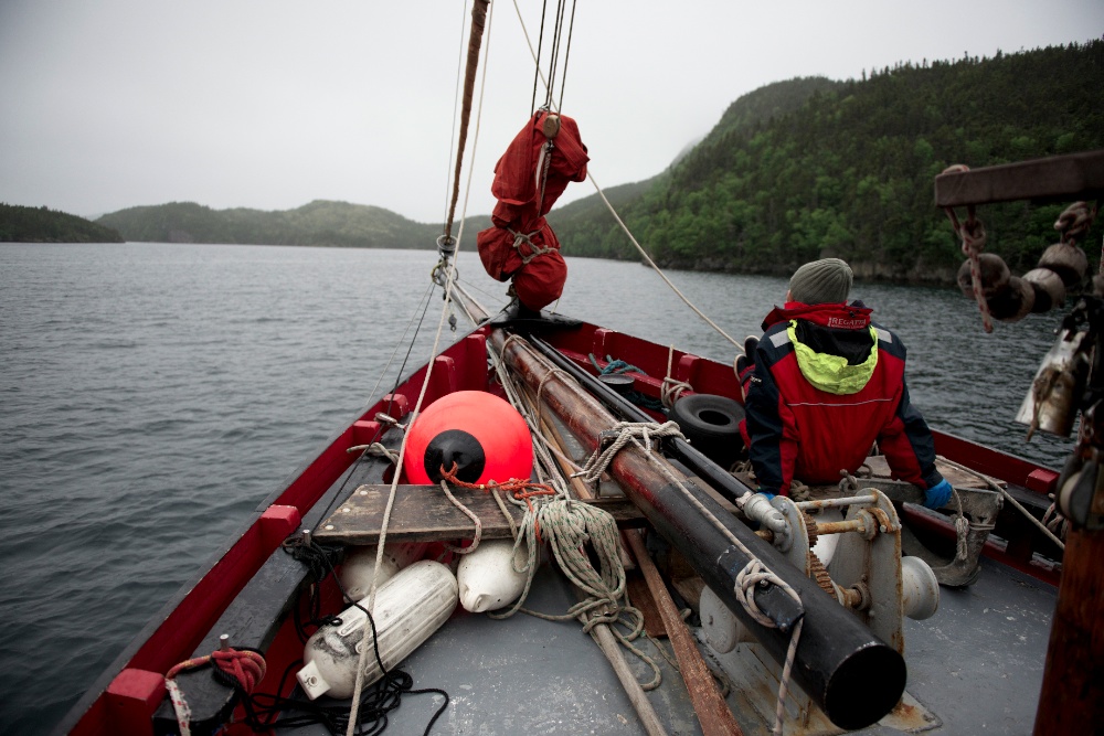 There is a place on earth that is perfect to study climate change. It’s the Canadian island of Newfoundland, surrounded by the Atlantic Ocean. In the North, the cold currents from the Arctic usually bring floating icebergs close to the shore. In the South, the Gulf Stream brings up the warm waters that were once in the Caribbean Sea. Newfoundland is a crossroad where impacts can be seen, quite literally.
Ironically, it is right next to the only place in the world that is actually getting colder. Ask any local if they felt some warmth during their summer months of June and July 2015. Scientists have come up with one theory about this “cold blob” that is globally accepted. So much ice is supposedly melting from Greenland, that surrounding sea water is getting less and less salty. Simply put, cold and salty water usually sinks to the bottom of the ocean, sucking in warmer waters to replace it at the surface. With billions of cubic meters of fresh water that used to be solid ice, the cold water doesn’t sink anymore and the warm waters from the Equator are no more pumped up. The Gulf Stream, which is part of the gigantic and vital current named Atlantic Meridional Overturning Circulation, slows down so that the cold stays cold, and the warm stays warm. It’s bad news, and it’s exactly what the scenario of the 2004 climate science disaster movie “The Day After Tomorrow” is about. But don’t worry, experts say nothing of that sort will happen in such a short period of time.

Nevertheless, the rest of the world is heating up, and the specialists are already stating that 2015 will be a record-breaking warm year. One of the main reasons for this abnormal heat can be found once again in the sea. Especially when it’s the largest body of water on the planet we are talking about. When the Pacific Ocean is slightly above its average temperature, it has the power to influence most of the world’s weather. Please welcome El Niño, one of the climatic cycles that is most feared and anticipated, depending on where you live.
El Niño and climate change are often associated, but they have very little to do with each other. The fact is that the years with a powerful El Niño Southern Oscillation (also shortened “ENSO”) have historically been the warmest years on record. And guess what? Scientists are currently (end of 2015) monitoring the biggest ENSO in history. Warmer than usual waters are building up in the center of the Pacific, and spilling all the way to the coast of Mexico where Patricia was patiently waiting to get her free shot of hurricane steroids.
To fully understand what an ENSO is, we need to look at what “normally” happens in the Pacific, if there ever is anything considered normal. A low pressure system is usually over Indonesia while an opposing high pressure system is over Peru in South America. The trade winds blow from East to West to compensate the pressure difference, pushing the warm surface waters towards Asia where they will evaporate and create the monsoon. In Peru, all this warm water blown away is replaced by cold water that is sucked up from the depths of the Pacific, attracting cold-water fish such as anchovies. Asia gets the rain it needs for its rainforests, the fisherman in Peru fill up their nets, everybody is happy. But every two to seven years, mother nature shuffles the cards.
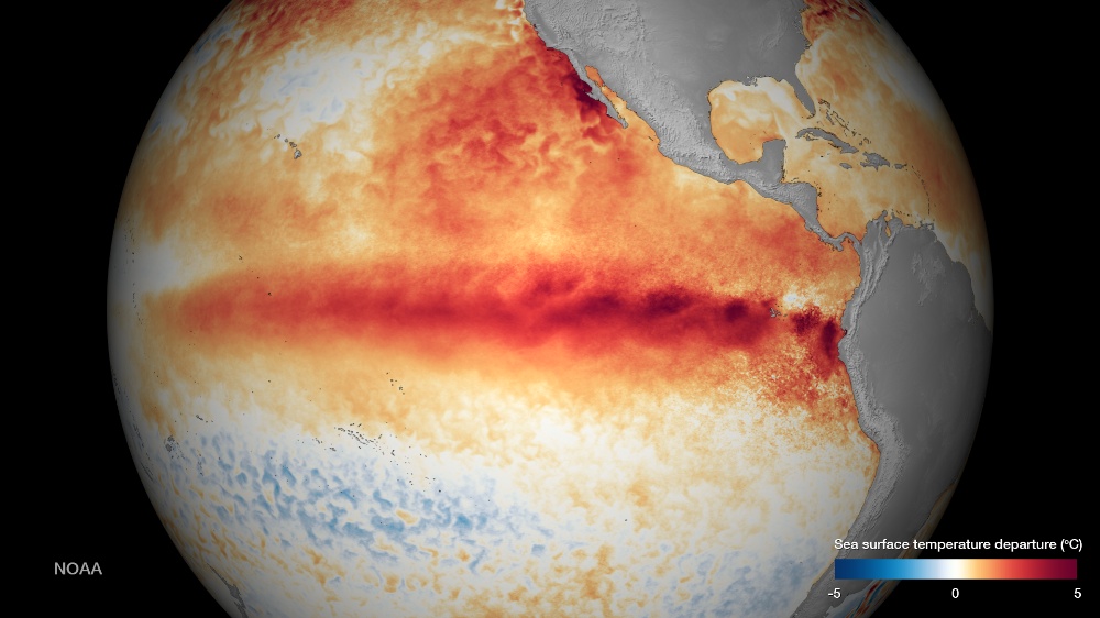
In 1997 for example, the difference between the high and low pressures across the Pacific decreased to the point where the trade winds stopped and even switched. Therefore, the warm water close to the Equator had nowhere to go. The heat built up in the Eastern Pacific where it shouldn’t, and triggered the most violent ENSO in records. Up until a few months ago.
«The big El Niños have historically come out like tongues in the Eastern Pacific, like in 1993 or 1997-1998, says Katy Hill, the oceanographer at the World Meteorological Organization. But since the 2000s, we’ve had these weaker Central Pacific El Niños. Their dynamics have been different, because the ocean’s abnormal temperature manifests in another place, and therefore the impacts aren’t the same».
With an extremely strong Eastern ENSO, Indonesia and Australia are subject to droughts and wildfires. On the other side of the Pacific, California, Mexico and Peru receive excessive rainfall which mean floods and mudslides. With a weaker central oscillation, the impacts are mitigated. Katy Hill adds: «2015 is looking to be a big El Niño, but developing in the Central Pacific.» Right, so the effects won’t be as devastating as in 1997-1998? «The only thing we can say for sure about the Tropical Pacific, is to expect surprises. Because as soon as you think you know and understand the system, it delivers a surprise.» In a nutshell, all we can do at this point is brace ourselves, and wait for the aftermath to analyze the impacts.
There are many other oscillations happening in our seas and oceans, but ENSO usually receives the most attention not only because it happens regularly, but because of the extent of its effects. Apart from the drought and the flooding in neighbouring countries, El Niño is so powerful that it can indirectly impact regions that are thousands of kilometers away. So many people are affected that there are now dozens of scientific programs that study the chain of climatic events. This cascade of global impacts is called teleconnection.
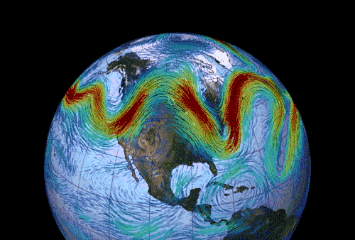
An example of teleconnection is the bending of the jet streams. These high-altitude high-velocity rivers of air govern most of the world’s short term weather, especially in Western Europe. Like a river made of water, they follow the path of least resistance, and when they are left alone, they try to flow in a straight line, from East to West. But with a strong El Niño for example, excess heat reaches the upper atmosphere and pushes the air river away from its airbed. Katy Hill from the WMO calls it «wobbles in the jet stream.» Once this wobble is firmly locked into position – called an Omega Block because it looks like the Greek letter – it can create long lasting weather patterns. «These big wobbles in the jet stream, says Katy Hill, are the reasons why we are seeing memorable heat waves in Europe with droughts, and then polar vortexes over the east coast of the USA and also heat waves on the West coast of the USA.»
We have to admit that most of us felt something was going on in 2015. Many locals around the world have been caught saying: «I’ve never seen anything like this before.» Ben Freeston from the Magicseaweed surf forecast website rationalizes: «Extreme events are very much an issue of perspective. In any given year, we will see extremes all over the world. This is just the nature of statistical variations we might expect over time and space.» True enough, but with so many records broken in 2015, this year will most certainly stand out.
Coincidentally, the COP21 – known as the 2015 Paris Climate Conference – will take place in early December. At this crucial summit, no less than 190 nations will discuss a new global agreement on climate change. The current agreement is known as the Kyoto Protocol and was signed in 1997. It was supposed to end in 2012 but was extended in extremis. Experts from all over the world are clear: if we don’t want a catastrophic and irreversible situation in our hands, we need to control the greenhouse gases emissions so that global warming doesn’t exceed 2°C. Of course, reducing our CO2 output will not make all our problems instantly disappear. But at least we will stop trying to extinguish a wildfire by throwing buckets of kerosene at it.
Unfortunately, the past summits have often neglected the role of our oceans. «If you want to understand what is happening with the weather and climate on a scale beyond a week or 10 days, says Katy Hill, you need to consider what is happening in the ocean as part of the information base. It has the largest memory in the climate system.»
Let’s hope the leaders at the COP21 summit in Paris will not lose theirs, and remember that nature has clearly voted more than once in 2015.